
Collecting Ocean data 4000 meters under drifting Arctic ice

Four months have passed since we made it back from the Aurora Vent Fields. Some of the scientists on the ship have received their samples at their home labs, but not all. Retrieving these samples started with a rush of fear and worry at the deepest place in the Arctic Ocean.
My name is Cera McTavish, and I’m the Marketing and Business Developer at C4IR Ocean. C4IR Ocean’s role is small, but our sister organization REV Ocean played a significant role in this expedition called the HAKON 21.
On a hunt for Ocean Data and a better understanding
The 17 scientists onboard the R/V Kronprins Haakon are all hunting for data to better understand the ocean. Or, more precisely, data from the Aurora Vent Field and how its fauna has evolved.
The HACON 2021 cruise was led by professor Stefan Bünz from the University of Tromso: Centre for Arctic Gas Hydrate, Environment and Climate and Dr Eva Ramirez-Llodra, from the Norwegian Institute for Water Research and REV Ocean.
The team first visited the vents in 2019.
I was fortunate to join the HACON 21 expedition on one of my most exciting trips ever. This story picks up right after my previous blog.
Everything goes well at first
We arrive at Molloy Deep at 7:30 in the morning, one day after our successful shallow test dive in Isfjorden.

Map of the general area indicating the 3 study areas. 1: Molloy Deep; 2: Aurora Vent Field; 3: NE Greenland Shelf. Source: HACON Cruise Report
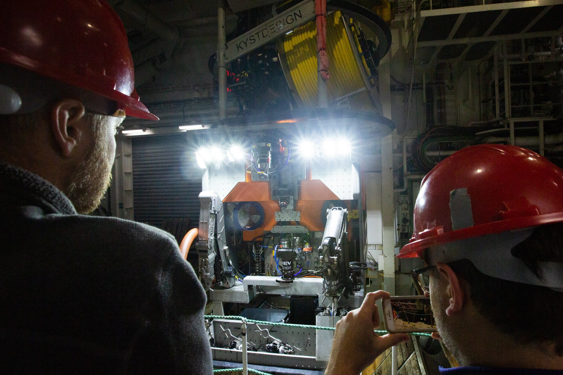
The Molloy Deep is the deepest part of the Arctic Ocean, 5,550 meters. We are here to test-dive the ROV (Remotely Operated Vehicle) Aurora, the last open water test before the pressure increases with diving and operating the ROV under Arctic Sea ice at the Aurora Vent fields. We are dependent on everything going smoothly here at the Molloy Deep. And, of course. It doesn’t.
We start the test dive with ROV Aurora. All is going smoothly as the ROV engineers test several system components.
Source: Lawrence Hislop
And then
A final test: unravel and recoil the entire length (1000 meters) of the TMS (Tether Management System) umbilical cord connecting it to the ROV. With 200 meters left to recoil to dock the ROV to the TMS, both pieces of equipment go silent.
We lose all communication with ROV Aurora and TMS Borealis. Somewhere on the seafloor at the deepest place in the Arctic Ocean, ROV Aurora and TMS Borealis (market value worth a few million USD), weighing 22.000 kg, have stranded.
A separate responder on ROV Aurora transmitting a signal to the ship confirms the ROV has been stranded on the seafloor. We quietly wonder if the expedition is over before we even made it to the Aurora Vent fields and the Arctic ice. There´s nothing most of us can do except just go to bed.
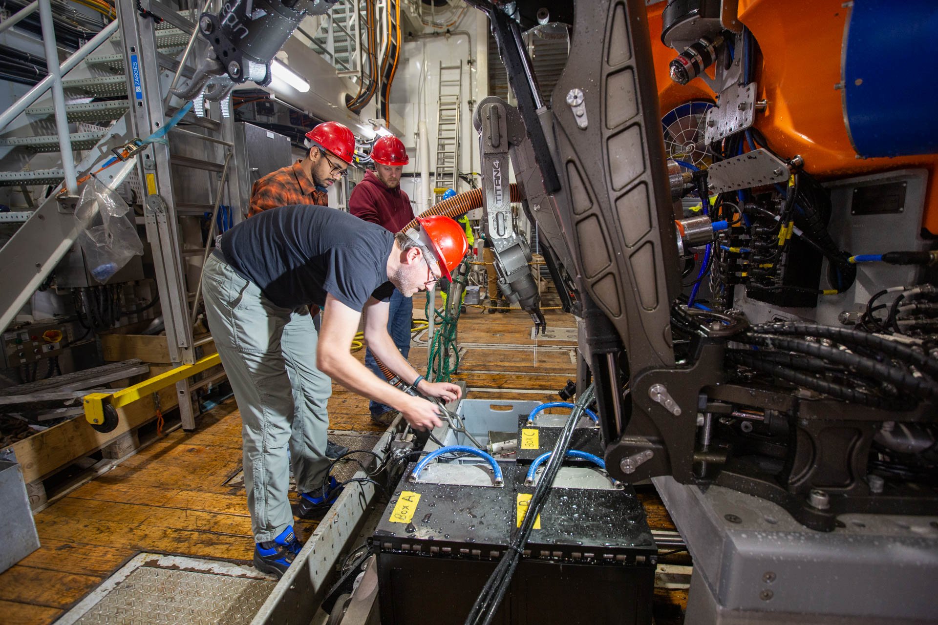
A small team of four engineers will work through the night to see if the ROV can be recovered. There is so much at stake.
The art of engineering
We wake up moving full speed for the Aurora Vent Fields the following day. The Molloy Deep is 150 nautical miles behind us. And miraculously with ROV Aurora and TMS Borealis on board.
And here follows my imperfect eulogy for the fantastic team of engineers on board who managed to restore communication with the ROV Aurora while on the deepest seafloor of the Arctic Ocean.

The fibre-optical wire is invisible to the naked eye, protruding from the red wire in the photo.
The ROV team isolated a fibre-optical wire, the size of a single strand of hair, that had broken, shutting down all communications between the team of engineers in the ROV control room with the equipment on the seafloor.
For the amount of hydraulics and electronics the ROV team is working with, it is astonishing that something invisible to the naked eye could shut down 22,500 kgs (about twice the weight of a school bus) of equipment. They strip the wire and repair the issue on board before lunchtime.
A strange feeling of feeling both vulnerable and secure
After the anxious evening, it´s hard to believe we will ease Aurora back underwater at all, let alone add the complexity of the ice cover.
This problem has exposed us to the calculated risk of how many things can go wrong in the middle of nowhere, doing something that has never been done before.
It is a strange feeling, fear combined with growing confidence that our competent engineering team will save the day if something happens. Still, the ROV team´s troubleshooting restores confidence that we have a team capable of making history.
We forge ahead on our way to the Aurora Vent Fields.
Utterly dependent on Ice Drift Models
The Cruise Lead, Stefan Bünz, hosts daily science meetings to walk us through the predicted ice drift over the next twenty-four hours. A satellite passes by us only once or twice early in the morning to send us updates on the ice.

Stefan Buenz during the daily science meeting explaining the ice drift predictions for the following day. You may notice that we only manage to download the most important data tiles in higher resolution. Source: HACON Cruise Report
An example of how to isolate areas (tiles) of interest to download sea ice concentration as demonstrated within 4G range. Source: Drift+Noise Instagram
Here is a demo of how Drift Noise Prediction software works. It details the three map layers: Sea Ice Concentration, Ice Drift Forecast, and Sentinel 1
Ice-drift predictions come from the company Driftnoise, located in Bremerhaven, Germany. A team of specialists uses a coupled ocean-sea ice data assimilation system for the North Atlantic Ocean and Arctic Ocean (TOPAZ4) to model sea ice drift over a period of 48h. The model is trained using in-situ observations of ice drifter buoys regularly deployed during research cruises into the Arctic Ocean, e.g. by the Alfred Wegener Institute on their icebreaker Polarstern.
Even with month old behavioral data modelled with real-time ice conditions, the ice is unpredictable. Stefan ensures that the modelling has improved since he visited Aurora in 2019.
Incredibly noisy!
Tucked into the ice floe, R.V Kronprins Haakon stabilizes. We transition from mimicking/shadowing Arctic waves to calmly drifting with the ice.
Locked in the ice, it seems we could be anywhere on land. Only once the ship nudges forward, splitting the ground, does the land open into a black void kilometers below. The ice resembles a desolate snow-covered abyss.
I had been warned about the sound of the R.V Kronprins Haakon breaking through ice. I felt prepared with a box of earplugs and my noise-cancelling headphones. The reality is nothing can block out the sound of ice one meter thick being crushed below a 9000-ton Icebreaker.
RV Kronprins Haakon tucking into the Arctic Sea Ice.
The Ice floe pushes us forward during the dive
We needed to be pushed by the ice to measure the real-time ice drift. So, what we did was try to get to the correct position through a lead (a small area of thin ice the ship can break), and then get stuck on the ice floe to be pushed by the ice for 20 min, to ensure that the direction was the one predicted, and confirm the floe drift speed.
This was used to calculate when Aurora should deploy through the moonpool to ensure enough time to dive to the seafloor (approximately 1.5hours) ahead of the vent field. The vessel would drift over the vent field (or close enough), so Aurora would have some time to work there. Before long, Aurora must start swimming to catch up with the ship before the underwater leash gets too short.
The ship is constantly repositioning (read: crashing through the ice during sleeping hours) so we can play this game of tag between the ship and the ROV as many rounds as possible.
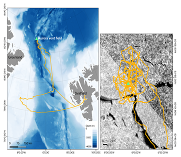
Shiptrack for RV Kronprins Haakon during the HACON21 cruise, and shiptrack over the Aurora Vent Field (green triangle) over an ice satellite image. Source: HACON Cruise Report
We manage six successful dives to the Aurora Vent Fields despite the challenging ice conditions!
In open water, ROV dives can last a whole day, or possibly longer depending on objectives and sampling operations, giving scientists plenty of time to get samples.
Generosity and precision
Under the ice, the scientists must campaign to be in the ROV control room on each dive to prioritize their samples as dives on the Aurora vent field lasted from 25 minutes to just over two hours of seafloor time.
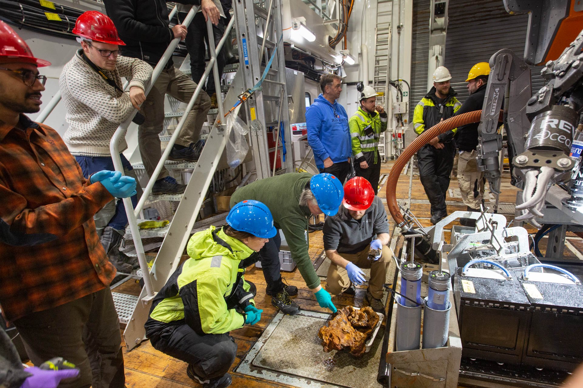
Scientists patiently awaiting ROV Aurora to arrive on deck to collect and preserve their samples. Source: Lawrence Hislop
The scientists are punctual in meeting the ROV as it surfaces. Due to the limited time, they are hospitable with the samples received, sharing what they get. Chemists take the first samples, rushing them to the freezer. Next, microbiologists search for microscopic fauna, and biologists take the small animals that live on the rocks. Lastly, the geologists take what is left of the stone to their lab to dry it for later processing and analysis onshore.
Everyone is very considerate about their equipment, careful that their inspection does not compromise the following scientists down the line.
The HACON team has taken a significant step forward in deep-sea exploration – sampling one of the last remote and inaccessible seafloor environments - the depths of the Sea Ice Arctic Ocean.

An example of how one blade core is shared amongst multiple institutions and many different scientists within those institutions. Source: HACON Cruise Report
We need ocean data for better insight and understanding
When we were in such remote places, we were heavily reliant on limited data. everything from viewing surface ice drift predictions from satellites to diving 4000m to the seafloor with robots.
We arrived at the Aurora vent field with an aerial 500m resolution seafloor map. Now we can provide future explorers with a three dimensional 25m resolution seafloor map.
It is clear to me that the ocean’s depths are the frontier of the decades ahead. We have a relentless journey ahead of us to work together to share data fast enough to help our fellow explorers understand the world beneath us.
What surprised me the most on this journey is that many of the sample analyses are not completed until weeks or months later when the samples arrive in Mainland Norway, Portugal, and Canada. The labs on board are more for documenting and organizing samples, preserving fauna, initial chemistry reactions, and drying rocks.
The time invested in getting answers from a remote location is cumbersome, therefore we need to share data results fast and far when we have them. The data that is analyzed from the samples adds insight for future students on where these organisms may have originated. We can learn more about the ecosystem by sharing the organism data with a better map to a global audience. A better understanding of the ecosystem can guide us on how we can restore it, changing the fate of the ocean.
“So, you won’t know what you really found until you’re home?” I asked multiple scientists enamored. I guess we’ll just have to come back if we miss something. And that is 100% ok with me.

Seafloor bathymetry and structure of the Aurora Seamount obtained from multibeam surveying during the 2019 HACON cruise. Source: HACON19 Cruise Report

Three-dimensional view (facing approximately north) of the seafloor bathymetry and structure of the Aurora seamount obtained from multibeam surveying during the HACON21 cruise. Source: HACON21 Cruise Report